
In the field of water resources engineering, hydrologic and hydraulic modeling is a tool commonly used for engineering analysis and to evaluate the benefits of proposed improvements. Hydrology represents the quantity of water (runoff) generated from a specific area or watershed. Hydraulics deals with the physical properties of water, such as calculating the depth of flow in a pipe or open channel. A combined hydrologic/hydraulic model allows us to evaluate the impacts of various improvement scenarios and the benefits that would be achieved.
A recent project example is a model analysis Civiltech provided for the Village of Berkeley. Located in western Cook County, Berkeley is an urban area drained entirely by a separate storm sewer system. Over the past five years, the Village has experienced a significant increase in the frequency of local flooding due to stormwater runoff. This stormwater runoff creates significant roadway ponding that blocks emergency vehicle access as well as floods homes and yards. Civiltech provided an existing and proposed condition hydrologic/hydraulic model analysis to determine the cause of the flooding and to develop and evaluate potential engineering design solutions.
The existing and proposed hydrologic/hydraulic analysis was developed using the Environmental Protection Agency – Stormwater Management Model (EPA-SWMM) analysis software. EPA-SWMM is a public domain software that combines hydrology and hydraulics, allowing a detailed and complex analysis. The model simulates dynamic rainfall-runoff routing and transporting the runoff through storm sewers, channels, and pumps.
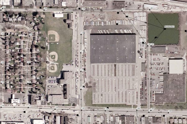
Overview of Village of Berkeley Detention Basin and proposed relief sewers.
For the hydrologic analysis, the Village was divided into four major watersheds. The northern sub-watershed, which experienced the majority of the flooding, was modeled in the most detail. The hydrographs developed for each sub-watershed were then used in the storm sewer hydraulic analysis.
The existing hydraulic analysis looked at the storm sewer pipe sizes, rims, and invert elevations taken from the Village’s storm sewer utility atlas. The results of the existing condition, 100-year analysis showed flooding in the areas where the computed hydraulic grade line is above the manhole rim elevations. The flooding generally occurred in the lowest geographic areas since the storm sewer had limited capacity and was overwhelmed during the modeled 100-year storm. The results of the model verified the flooding conditions that had been historically observed by the Village.
The EPA-SWMM model allowed an analysis of alternative design solutions. An alternative was developed that included adding two relief sewers and expanding an existing Village stormwater detention basin. The proposed relief storm sewers would divert stormwater at two critical locations where a majority of the existing flooding occurs. The proposed condition hydraulic model demonstrated significant improvements to the existing condition. The lowering of the existing basin required a stormwater pump station to be installed that was also incorporated in the model. The proposed detention basin improvements provided an additional 34.6 acre-feet of storage having a significant impact at existing locations during flooding events and providing benefits to downstream communities.
The engineering and hydrologic/hydraulic model analysis of the proposed Village of Berkeley Flood Control Project illustrates the significant benefits that can be achieved as a result of the proposed improvements, including:
- The proposed relief sewer is able to divert a significant amount of stormwater to the detention basin such that the 100-year hydraulic grade line is reduced by several feet in areas of chronic flooding.
- The proposed flood control project will directly benefit approximately 800 homes.
- The proposed improvement will provide an additional 34.6 acre-feet of detention storage during the 100-year 24 hour design storm event.
By developing the SWMM model, Civiltech was able to identify problem areas through simulation and to evaluate the benefits of specific solutions. The model was featured in presentations to various agencies to procure funding. Grants for the proposed improvements have been obtained from MWRD, Cook County, and the State of Illinois.