The Chicago Neighborhood Engineering and Construction team, or C*NECT, has been providing comprehensive engineering support services across all Chicago communities. One large initiative assigned to the C*NECT team is to analyze and document the pavement condition of every residential street throughout the City. Civiltech led this effort three times, first in winter of 2014/2015, then in 2017/2018, and again this last summer and fall, with the 2020 survey being completed before Thanksgiving.
To adequately and equitably prioritize improvements across all City neighborhoods, C*NECT needed a roadmap – a way to survey the condition of every street across the city, a rating system or way to gauge criteria, and a tool with which to collect and document the massive quantity of data in a system that is easy to understand, access, and apply. Civiltech was tasked with setting up the technology needed to accomplish this with Kristen Hahn, P.E., PTOE, managing the oversite and providing quality control.
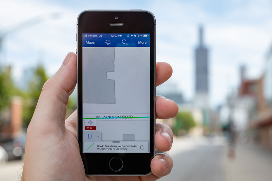
Utilizing Geographic Information System mapping (GIS), the team first built an online base map. The map was then customized for viewing and data collection in ArcGIS Collector, a smartphone app available from Esri, an international supplier of geographic information system software, web GIS, and geodatabase management applications.
Civiltech customized the Collector App with specialized symbols and data input ability specific to the project needs. As a result, each C*NECT surveyor was able to drive into a neighborhood, stop on every block, assess the pavement and roadway conditions, take photos, input their analysis and photos into the Collector App on their smart phone, and post data to the online base map where it could be instantly viewed by others.
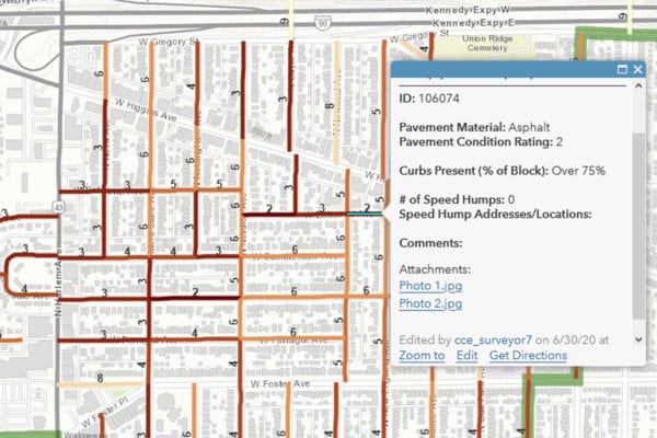
During the first two rounds of this task, the criteria for pavement condition analysis was “good, fair, poor, or very poor”, with Civiltech providing examples of each. For the 3rd and most recent round of the data collection, Civiltech began utilizing the Pavement Surface Evaluation and Rating, or PASER system. PASER, developed by the University of Wisconsin-Madison Transportation Information Center, provides a basis for visually rating and comparing the surface condition of a pavement with a scale of 1 to 10 – 1 being a failed pavement condition and 10 being excellent condition.
The survey process includes analyzing the pavement condition as described above; documenting it with a photo; noting if there is curb and gutter; noting if there are speed humps and if so, how many; and noting if the street includes a traffic circle. As the surveyors put data into their phones, it is immediately applied to the map. Then, the road as represented on the map, changes color to identify both that it has been analyzed and its condition. With the color coding on the map, it is easy to identify what has been completed, what still needs surveyed, and the condition rating.
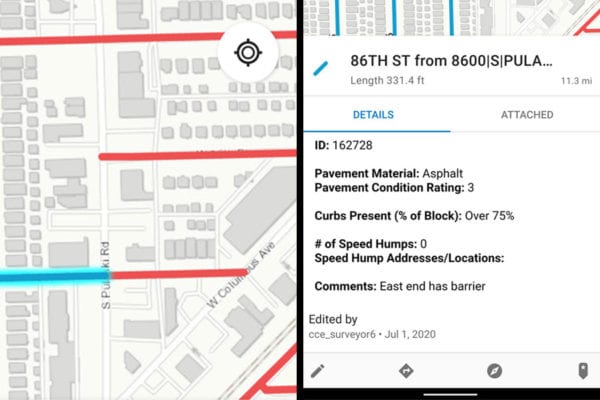
The data is also included in a city-owned online mapping system that displays information on infrastructure conditions and planned construction projects, where it is available to key decision makers. Aldermen can view a map of their ward and easily ascertain the most recent pavement data. This information is beneficial to prioritizing the individual ward’s infrastructure project needs.
Beyond the individual ward level, Chicago uses the data to prioritize City-wide construction projects in an equitable, data-driven way. Civiltech and City staff work together to score potential resurfacing locations by combining pavement condition data with other factors. Points are assigned to each bock for conditions such as poor pavement condition, location within a vision zero focus area, high community hardship rankings (based on income and education levels), or planned bikeway locations. The point system allows more weight to be given to the factors that are more important, and it can be adjusted to address each program’s individual goals. Once total priority scores are calculated, each block is color coded and mapped. This helps City officials decide how to direct limited resources toward the greatest need as they develop multi-year capital improvement plans. Civiltech and City staff have used this type of scoring system to prioritize arterial resurfacing projects for 2019 through 2021, and we are currently applying priority scores to local bond-funded resurfacing on streets that not eligible for Chicago’s arterial resurfacing program.
We look forward to continued collaboration with Chicago on these types of data collection, mapping, and scoring tasks as officials take on the challenge of building equitable, efficient multi-year plans to maintain and improve the City of Chicago.