When a “What If” Idea Prompts an Exciting New Application of an Existing Technology
At Civiltech, we strive to be innovative in how we work, in our studies and design solutions, and in our use of technology. Recently, those nodes of innovation collided, and a “what if” idea prompted a new use of an existing technology resulting in an exciting project outcome that proved beneficial to a client. More specifically, our Traffic and Phase I teams utilized our existing in-house drone program to gather data for a complex Origin-Destination (O-D) Study.
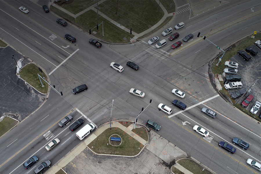
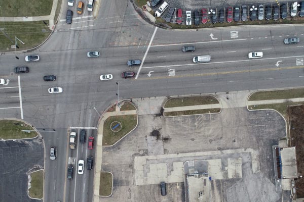
Civiltech was asked to perform the O-D Study as part of our Finley Road/Belmont Road/Ogden Avenue Intersection Phase I project for DuPage County. The purpose of the study was to evaluate potential route alternatives for traffic within the study area. This complex intersection experiences heavy existing traffic volumes that are expected to increase through the 2050 design year. The evaluations at this intersection required a consideration of the operation and travel patterns along the four roadways within the trapezoidal study area: Finley Road/Belmont Road, Ogden Avenue, Cross Street, and Warrenville Road. The purpose of the O-D study was to gain an understanding of where vehicles are going when they travel through the intersection in relation to where they came from. This snapshot of the traffic patterns and trends was beneficial to developing meaningful alternatives for correcting the various problematic components of the intersection and study area.
Conventionally, to conduct an O-D Study such as this, our team would place staff in different locations at the perimeter of the study during the a.m. and p.m. rush periods. They would dictate license plate numbers into voice recorders with other staff noting where vehicles entered the study area and where they exited. This often involved a half dozen or more staff. The data would then be compiled and analyzed using a labor and time intensive process.
Finley Road/Belmont Road/Ogden Avenue Intersection
Civiltech’s Jim Woods, P.E., PTOE floated the idea that if we could use our drone technology, not only would the exercise be less labor and time intensive, but the data would be captured on video and more accurate and traceable than if it were captured by people recording what they observed. Jim spoke to Adam Wuellner, CAD Manager and vanguard of Civiltech’s drone capabilities, who thought the idea had merit and recommended working with two drones to capture different parts of the study area simultaneously. The team then proposed the idea to the client who agreed to give it a try.
Adam, together with Ernest Williams, also a Civiltech drone pilot, wanted to capture the movements of all vehicles through 3 of the 4 intersections in the study area. They deployed two drones on opposite sides of the study area during a.m. and p.m. peak hours. Adam then converted the drone recordings into a single video file for the entire study area. Civiltech Traffic Engineer, Anmol Shrivastava, P.E., PTOE was then able to compile the data supported by visual verification and analyze the traffic patterns for every traffic signal cycle for a full hour.
Certain challenges had to be addressed prior to this undertaking. A primary challenge was the battery life of the drones. The objective was to capture a full hour of video, but the drone’s battery life is only 20-25 minutes. The pilots dealt with this by flying in 20 minute intervals with two 5-minute break periods to swap out batteries.
There was also a concern as to whether the video quality would provide a useful end product since it would not be possible to capture license plates. The imaging came out clear, and vehicles were easily tracked as they traveled through the intersections.
Weather is always a factor in flying the drones as well as the location of the sun. While the weather was fine for this study, sunrise and sunset presented a challenge. The team had to wait to schedule the study until sunrise occurred earlier than the a.m. peak hour of data collection. Prior to this, not only would it have been too dark, but it is also illegal to fly more than 30 minutes before sunrise or after sunset. This is a notable challenge as it limits the viability of utilizing drones in this capacity to about 6 months out of the year.
The Civiltech team felt that the exercise was a success and proved beneficial to the client. Using the drones for the O-D Study provided a cost savings to the client by creating efficiency in the time needed to conduct the study and the minimal quantity of staff it required. Also, capturing a full hour of traffic movements on video resulted in more accurate and comprehensive data.
Anmol summed up the success of the experience and the enthusiasm of the team stating, “I feel like this is the future for capturing data. From the drone’s birds-eye view, the video captures all the data you need. You can see the collective functioning and intrinsic nature of the intersection and entire area.”